


Paragliding Map
คำอธิบายของParagliding Map
แอพบินฟรียอดนิยมที่สุดในโลก!
แหล่งข้อมูลเว็บไซต์ พยากรณ์อากาศ เว็บแคม รูปภาพ และอื่นๆ ที่ครอบคลุมที่สุด!
ดูว่าคุณสามารถบินได้ที่ไหนตอนนี้ ทั่วโลก!
▪ สำรวจจุดปล่อยจรวดมากกว่า 15,000 แห่ง การลงจอด 7,500 ครั้ง สถานีตรวจอากาศ 30,000 แห่ง และเว็บแคม 39,000 แห่ง
▪ ข้อมูลอย่างเป็นทางการจาก DHV, Flyland, FFVL, Paragliding Earth และอีกมากมาย
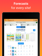
▪ พยากรณ์จาก Meteoblue, Windy และ WindFinder
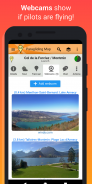
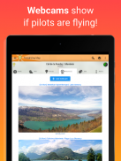
▪ เว็บแคมสด
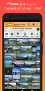
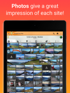
▪ ภาพถ่ายจะทำให้คุณประทับใจในแต่ละจุด
▪ แอนิเมชันลม - ดูเมฆ พายุฝนฟ้าคะนอง ฝน และลมในระดับความสูงต่างๆ
▪ น่านฟ้า - ดูน่านฟ้าและ NOTAM (ประกาศสั้น ๆ ข้อจำกัดน่านฟ้ารายวัน) บนแผนที่
▪ NOTAM อย่างเป็นทางการ - ดูประกาศถึงนักบิน (NOTAM) บนแผนที่จากหน่วยงานการบินระหว่างประเทศ คุณลักษณะด้านความปลอดภัยที่สำคัญสำหรับทุกเที่ยวบิน!
▪ คำเตือน NOTAM อัตโนมัติ - คำเตือนที่ชัดเจนจะปรากฏขึ้นเมื่อ NOTAM ที่ใช้งานอยู่ส่งผลกระทบต่อการเปิดตัวหรือการลงจอดของคุณ
▪ กรองแผนที่เพื่อแสดงเฉพาะการเปิดตัวของพาราไกลดิ้ง แฮงค์ไกลดิ้ง การบินเร็ว เทอร์มอลลิ่ง การทะยาน ไต่เขาและบิน การขนส่งสาธารณะ ความเร็วลม และอื่นๆ อีกมากมาย!
▪ ดูดัชนีทะยาน เมฆปกคลุม คำเตือนสภาพอากาศ และอื่นๆ อีกมากมาย!
▪ ผู้ให้บริการพยากรณ์อากาศหลายราย: UK MetOffice, German Weather Service, Meteo France, meteoblue, ECMWF, NOAA และอื่นๆ!
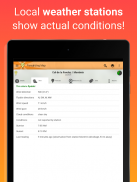
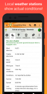
▪ ข้อมูลสถานีตรวจอากาศแบบเรียลไทม์จาก Pioupiou, Holfuy, MADIS และ FFVL แสดงสภาพอากาศตามจริง
▪ มุมมอง 3 มิติ
▪ เส้นทาง "เดินป่าและบิน"
▪ ลิฟต์สกี รถกระเช้า และเรือกอนโดลา
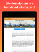
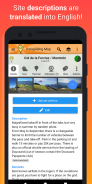
▪ การแปลคำอธิบายเว็บไซต์เป็นภาษาอังกฤษโดยอัตโนมัติ
▪ ดูสภาพการบินในอนาคตบนแผนที่โดยใช้ Time Travel Slider
▪ เส้นทางไปยังแต่ละจุดโดยใช้ระบบนำทาง
▪ สามารถบันทึกรายการโปรดเพื่อให้เข้าถึงได้ง่ายในภายหลัง
▪ การค้นหาขั้นสูง
▪ ส่ง “SOS!” และข้อความ “ฉันต้องการรถ” ถึงเพื่อน รวมถึงพิกัด GPS ของคุณด้วย
▪ ลิงก์ไปยังข้อมูลต้นฉบับจาก DHV, Flyland, FFVL และ Paragliding Earth
▪ ไม่มีการโฆษณา
▪ รวมการสนับสนุนเต็มรูปแบบ
ความคิดเห็นของคุณยินดีต้อนรับเสมอ ช่วยเราสร้างแอปร่มร่อนที่ดีที่สุดในโลก!
คุณลักษณะหลายอย่างของ Paragliding Map นั้นฟรี แต่ได้รับการสนับสนุนโดยการโฆษณา หากคุณเลือกที่จะทำการซื้อในแอป โฆษณาจะปิดโดยอัตโนมัติและการซื้อของคุณจะถูกเปิดใช้งาน (เว็บแคม การคาดการณ์ ฯลฯ)
Paragliding Map เป็นเวอร์ชันมือถือของ ParaglidingMap.com
นโยบายความเป็นส่วนตัวและข้อกำหนดและเงื่อนไขสามารถดูได้ที่ https://www.paraglidingmap.com/TermsAndConditions.aspx
Paragliding Map--เวอร์ชั่น11.7.0
(13-02-2025)Paragliding Map - ข้อมูล APK
เวอร์ชั่น APK: 11.7.0แพ็คเกจ: com.paraglidingmapเวอร์ชั่นล่าสุดของParagliding Map
เวอร์ชั่นอื่น


แอปในประเภทเดียวกัน


